- Editorial:
- MAPS INTERNATIONAL
- Año de edición:
- 2008
- Materia:
- Mapes murals mapesmundi polítics
- Idioma:
- English
- ISBN:
- 978-1-904892-74-8
- Encuadernación:
- Mapa cargolat
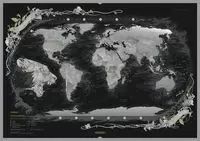
WORLD "UPSIDE DOWN" MAP
ESCALA 1:30.000.000
The world with the south on top! - 136 x 101cm (53.5" x 39.5" approx.) political map of the world with the continents turned up-side-down. Colouring and cartography are identical to the Maps International series of political world maps, with bold bright colours, vivid relief shading and prominent country names. English versions of all city names are used throughout. Within USA, Canada, Brazil and Australia internal state or provincial boundaries are indicated. Central Pacific, from Alaska/Siberia to New Zealand, is repeated on both sides of the map for better presentation of that region.
Clocks show time difference from GMT (but without the map indicating the exact geographical area covered by each time zone). A decorative panel under the map displays flags of various countries. Its interesting to see how both Russia and Canada appear much larger than on conventional world maps with the same Van der Grinten projection.
![MUNDO FISICO [MURAL] 48*68CM 1:58.000.000 -TELSTAR](https://www.muntanyadellibres.com/es/imagenes/9788415/978841534793.webp)