- EAN:
- 9789539578327
- Materia:
- Mapes murals mapesmundi murals infantils
- Idioma:
- English
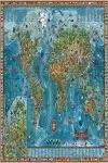
MAPAMUNDI INFANTIL IL·LUSTRAT AMAZING WORLD
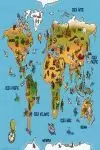
Wonderful, colorful map of world for children, filled with amusing images associated with various countries, regions and oceans. This large map, 138 x 89cm (36 x 211 approx.) is laminated, so can be written on with suitable marked pens.
The continents, with Europe also shown enlarged on a separate panel, are presented with colouring to show their topography and annotated with names of countries. Oceans show the sea floor ridges, continental shelf, etc. All are filled with 650 colourful and quirky, sometimes puzzling, images associated with different parts of the world, all numbered and listed in three separate panels on the map.
The map includes many educational features such as latitude and longitude lines, points of the compass, etc, and is surrounded by a border of national flags.
Whilst not completely rip-proof, the map is laminated and so much sturdier than paper, and can be drawn on with marker pens and then wiped clean.


