")
- Editorial:
- NORDECA
- Any d'edició:
- 2017
- Matèria:
- Guies i mapes excursionisme noruega
- Idioma:
- English
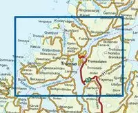
ULLSFJORDEN 1:50.000 (NORDECA 10156)
Map No. 10156, Ullsfjorden, in the new topographic survey of Norway at 1:50,000 covering the country on 195 double-sided sheets and first published by Nordeca in 2011 - 2012; fully GPS compatible, indicating waymarked footpaths, campsites, tourist huts, illuminated ski runs, etc.
The maps, now published by Nordeca, the successors to Statens Kartverk and its subsequent owners the Ugland Group, are printed on light, waterproof and tear-resistant synthetic paper. Each map covers an area of 62x45 kilometres (39 x 28 miles approx.), with a 2-km overlap between the sheets.
The maps have contours at 20m intervals (10m glacier contours), plus colouring and graphics to show cultivated areas, bogs, forests, etc. In addition to all the information expected of topographic mapping at this scale the maps distinguish between waymarked and unmarked footpaths and show campsites, tourist huts (serviced/self service/no supplies), country hotels and restaurants, and illuminated ski trails. The series uses EUREF89 (WGS84) datum and the maps have a 1-km UTM grid. Map legend is in Norwegian and English. Each title comes in a sturdy protective card envelope.